A varied route through forest, across alpine meadow and up mountainside with great views of Lac de Serre-Poncon, the Queyras and more. A perfect day's walk.
TOTAL DISTANCE: 9km
APPROXIMATE TIME: 3hrs 30mins
START: Foret Communale d'Embrun
FINISH: Foret Communale d'Embrun
Mont Guillaume lies to the west of Embrun; you cannot help but notice its forested flanks from the town. These flanks play host to many routes and objectives. Indeed, many tourists and young families come to Mont Guillaume not to climb the peak itself, but to see the Chapelle de Seyeres, which is approximately half way on this walk. For the more intrepid explorer, however, the rewards for ascending Mont Guillaume are fantastic views, as well as a couple of surprises on the way too.
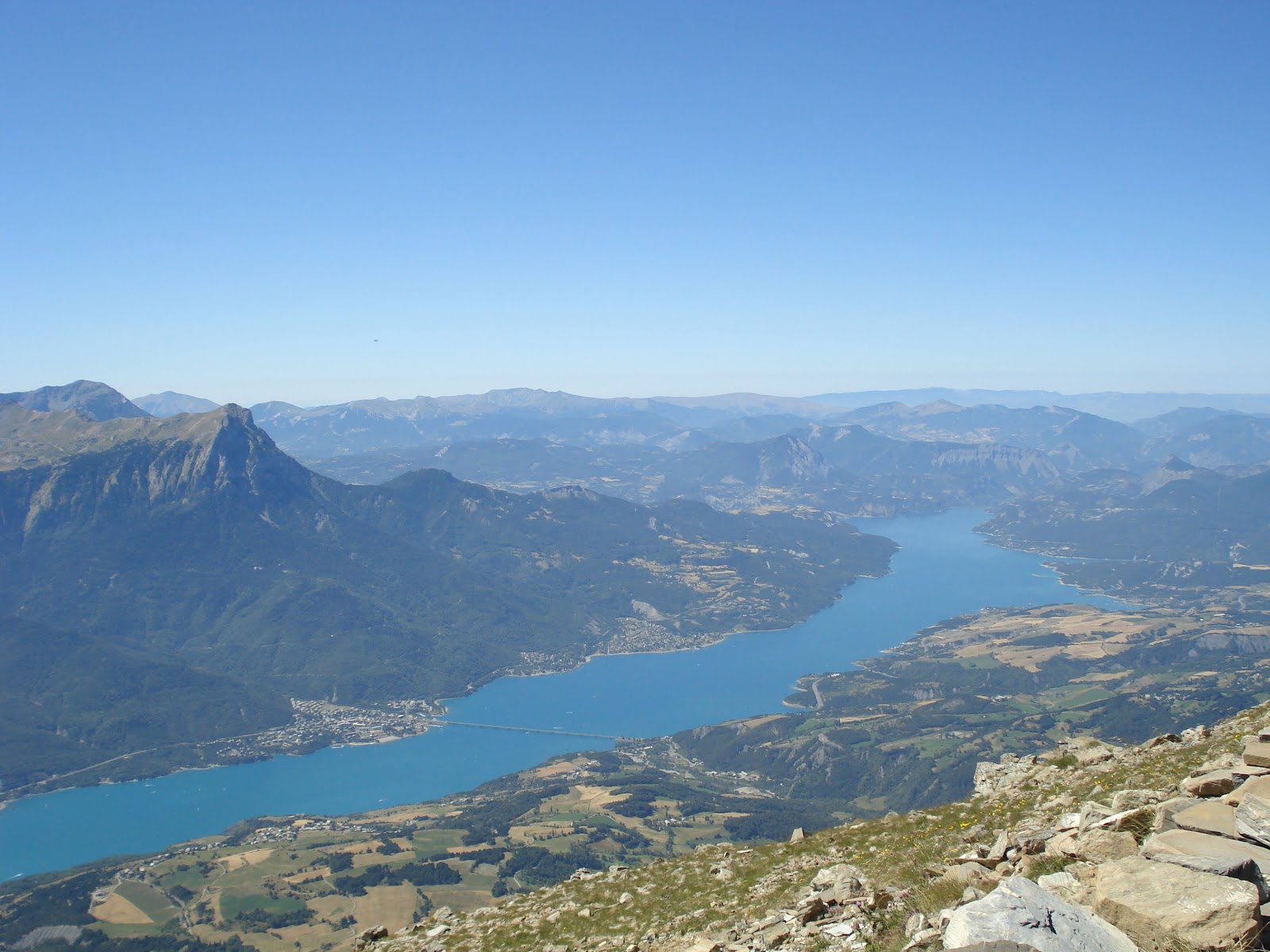 |
| The view of Lac de Serre-Poncon from Mont Guillaume's summit |
The walk begins at the car park at the entrance to the Foret Communale d'Embrun. This is a beautiful woodland, in which the sunlight forms in dapples beneath the evergreen trees. Take the path indicated by the sign "La Chapelle de Guillaume", which is a slanting little path up the hillside and through a gate in the electric fence. Continue to follow this path up through the forest - passing a small fenced-off plantation on your left - until you hit a larger track with signposts pointing in either direction.
This walk is signposted brilliantly - I haven't seen signposting as good as this since walking in the Pyrenees. Follow the track round to the left, until you come to another junction and another signpost. Of the three different routes, choose the one going round to the left (the one with the 'no vehicles' sign). Follow this round the contour of the hillside, and before long you'll be aware of the cattle which inhabit the Foret Communale, either by the sound of the cowbells echoing between the pines or because of the presence of droppings on the ground.
Soon you will stumble upon the signpost indicating the border between the Foret Communale d'Embrun and the Foret Dominale de Mont Guillaume. There appears to be a slight difference between the two: the Forest Dominale appears to be less ordered and has more deciduous woodland, though this may purely be because the terrain is somewhat steeper here on in. Look out for cattle in this area too. Continue along this wide track and you soon come to a junction, with one path leading down the hill, one leading up the hill, and the main track continuing along the contour. Take the path going up the hillside.
This path goes around the perimeter of the hillside, then doubles back on itself higher up. There is a drop on the left (and, later, the right) but the path is wide and safe enough for you to not even notice it. At the next signpost, turn left and carry along the side of the hillside. Then, at the head of this path, do as the signpost indicates and turn left.
Almost immediately after this junction, you begin momentarily to leave the woodland, entering a beautiful glade flooded with sunlight. Through the remaining trees you catch a glimpse of the view you will ultimately be gifted with, whilst picnic benches offer a great mid-point rest; there is even a water fountain for you to fill up your water bottles. The centrepiece of the glade takes the form of the Chapelle de Seyeres, a small catholic chapel whose location is only bettered by the Chapelle de Mont Guillaume, found on the very summit of the mountain itself.
 |
| The view from Mont Guillaume along the remaining ridge. The Aiguilles de Chabrieres can be seen to the south |
Continue through the glade, returning into the trees (though they are more sparse). At the next signpost, turn right up the hillside. Continue up through the remainder of the forest until the trees clear and you find yourself in a spectacular mountain corrie, with the crags ahead forming the wall of the alpine basin. The surrounding wild meadow is also perfect marmot territory, so look out for them.
The next section of the walk takes the form of long, snaking lassettes. These zigzag paths make the climb more gradual, and offer a longer amount of time to admire the beautiful basin.
Soon, as you traverse the contour of the hill , you will see a wooden cross on a mound ahead of you. You do not visit this cross (though you will visit another cross, namely the one found on the summit itself), though it makes for a good reference point. Just after first glimpsing this cross, you will come to a junction. There are two choices here which both lead to the top: a continuation of the zigzagging route on the lower path, which is a more gradual climb but longer; the higher path (indicated by the cairns) is a steeper, shorter climb up onto the hill. Take the latter.
Follow this higher track upwards then, and you will soon come to another junction. This time take the lower path; the other is an unnecessary shortcut which is steep and slippery.
Follow this path round and, soon, you will be able to see the wooden cross on the top of Mont Guillaume - not far to go. For a small section on this path you will walk through a small patch of wildflowers; the yellows, purples and reds add colour to the many greens and browns of the view.
This view is amazing: the entire eastern skyline is full to the brim with mountains. The points of the Queyras regional park dominate the northern part of this view, with the green mountains overlooking the Vars and Ubaye valleys completing the arc of montagne which concludes with the Pic de Dormilouse in the south. The juggernauts of Monte Viso and the Brec de Chamberons are two particular points of interest, not only because of their size but also due to their marking of the French-Italian border.
Continue the last few metres to the top. The wooden cross, now as symbolic to the humble walker as it was to the hundreds of Christian pilgrims, and the Chapelle de Mont Guillaume are there to greet you. To the south you can see the Lac de Serre-Poncon and the points of the Aigilles de Chabriere; to the west the hills on the periphery of the Ecrins national park block the wonders beyond, with the one exception of Mourefroid, which looms to the left of the trio of western peaks.
This is a lovely walk and, after spending a good while on the top, retrace your steps to see it all over again. This is a fantastic walk with fantastic views.
No comments:
Post a Comment